WinGLink is a multidisciplinary software program to process, interpret and integrate several geophysical disciplines in a unique interpretation model.
Primarily focused on Magnetotelluric data processing and modeling, for which it is the recognized worldwide standard, WinGLink® includes processing and modeling applications for gravity and magnetic data, as well as the capability to post information from vertical or deviated wells on maps and cross-sections to add model constraints.
WinGLink main modules are :
- Core Module : Database creation, project generation, coordinate conversion, import/export, mapping, profile construction, printing.
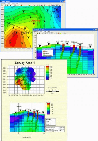
- Interpreted Views and Montage : Production of composite maps or cross-sections by superimposing maps or sections from different projects in the database. Creates interpreted views with user-defined lithological patterns, imported images, annotations and cultural data to integrate composite maps and cross-sections. Construct printing plates with multiple maps and cross-sections.
- Basic Processing up to 2D smooth inversion : Import sounding datasets, editing, static shifting/stripping, decomposition, TE/TM mode selection, 1D smooth and layered inversion, pseudo-sections, 1D model sections, extraction of resistivity and MT parameter maps, 2D (Randy Mackie) smooth inversion.
- 3D Forward Modeling : Construction of a 3D mesh via graphic, interactive editing tools. Import/Export of Randy Mackie format 3D Meshes. Extraction of depth maps and sections from 3D Mesh using “Maps” and “Cross-Sections” programs.
- Well stratigraphy and simplified log data : Import well stratigraphy and log data. Cross-sections showing well stratigraphy using custom-defined lithology patterns and symbols (deviated wells supported). Depth maps and imaged sections of interpolated log data.
- Time Domain Electromagnetic soundings : Import, edit and merge raw data from field dump files (Geonics, Zonge, Sirotem). 1D smooth and layered inversion, pseudo-sections, 1D model sections, extraction of resistivity maps.
An app that focuses on the gravitational force, astronomy, and circular motion.


Comments (1)