Combine and integrate multiple disciplines of geophysical measurement and calculation into interpretation models. Extrapolate and analyze gravity and magnetic data, generate readings for vertical or deviated wells. Place the data on maps and cross-sections.
WinGLink is a multidisciplinary software program to process, interpret and integrate several geophysical disciplines in a unique interpretation model.
Primarily focused on Magnetotelluric data processing and modeling, for which it is the recognized worldwide standard, WinGLink® includes processing and modeling applications for gravity and magnetic data, as well as the capability to post information from vertical or deviated wells on maps and cross-sections to add model constraints.
WinGLink main modules are :
- Core Module : Database creation, project generation, coordinate conversion, import/export, mapping, profile construction, printing.
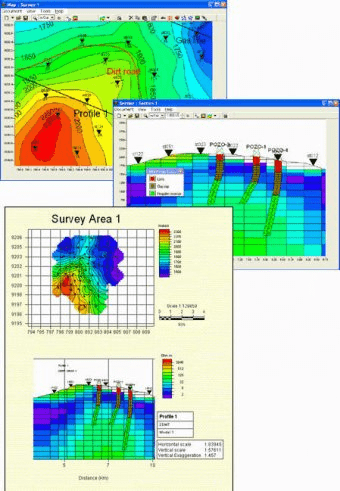
- Interpreted Views and Montage : Production of composite maps or cross-sections by superimposing maps or sections from different projects in the database. Creates interpreted views with user-defined lithological patterns, imported images, annotations and cultural data to integrate composite maps and cross-sections. Construct printing plates with multiple maps and cross-sections.
- Basic Processing up to 2D smooth inversion : Import sounding datasets, editing, static shifting/stripping, decomposition, TE/TM mode selection, 1D smooth and layered inversion, pseudo-sections, 1D model sections, extraction of resistivity and MT parameter maps, 2D (Randy Mackie) smooth inversion.
- 3D Forward Modeling : Construction of a 3D mesh via graphic, interactive editing tools. Import/Export of Randy Mackie format 3D Meshes. Extraction of depth maps and sections from 3D Mesh using “Maps” and “Cross-Sections” programs.
- Well stratigraphy and simplified log data : Import well stratigraphy and log data. Cross-sections showing well stratigraphy using custom-defined lithology patterns and symbols (deviated wells supported). Depth maps and imaged sections of interpolated log data.
- Time Domain Electromagnetic soundings : Import, edit and merge raw data from field dump files (Geonics, Zonge, Sirotem). 1D smooth and layered inversion, pseudo-sections, 1D model sections, extraction of resistivity maps.
Comments (1)